9/24/2025 – From the Facebook page Pascagoula River Trails History Else Martin
The Three-Chopped Way (1807-1819)
This map project on the Roads and Trails of Colonial America started by questioning what routes the immigrant ancestors used during their southern and western migrations. The assumption was that our earliest immigrant ancestors were limited to the waterways which accessed the coast and an occasional Indian path. And for the most part, that was true, However, further research proves that the Native population used trails and routes extensively to travel and trade throughout the hinterland and even to the coast. The challenge was for our early ancestors to identify the many routes and survive the journey.
Back before the Revolution, frontiersmen could walk from the Carolinas to New York on the old Indian path called the Warrior’s Path. This path ran east of the Appalachians down through the Valley of Virginia and up through the Susquehanna Gap into western New York. With American expansion west from the coastal regions, settlers found their way down the path into the hinterland.
A large section of the old Indian path became what we know as the Great Wagon Road which ran south from Lancaster PA, up through the Valley of Virginia, across the Up-country of North and South Carolina, down to Ft. Augusta GA. Thus, America’s first interior roads were Indian Paths. [Map of the Great Wagon Road]
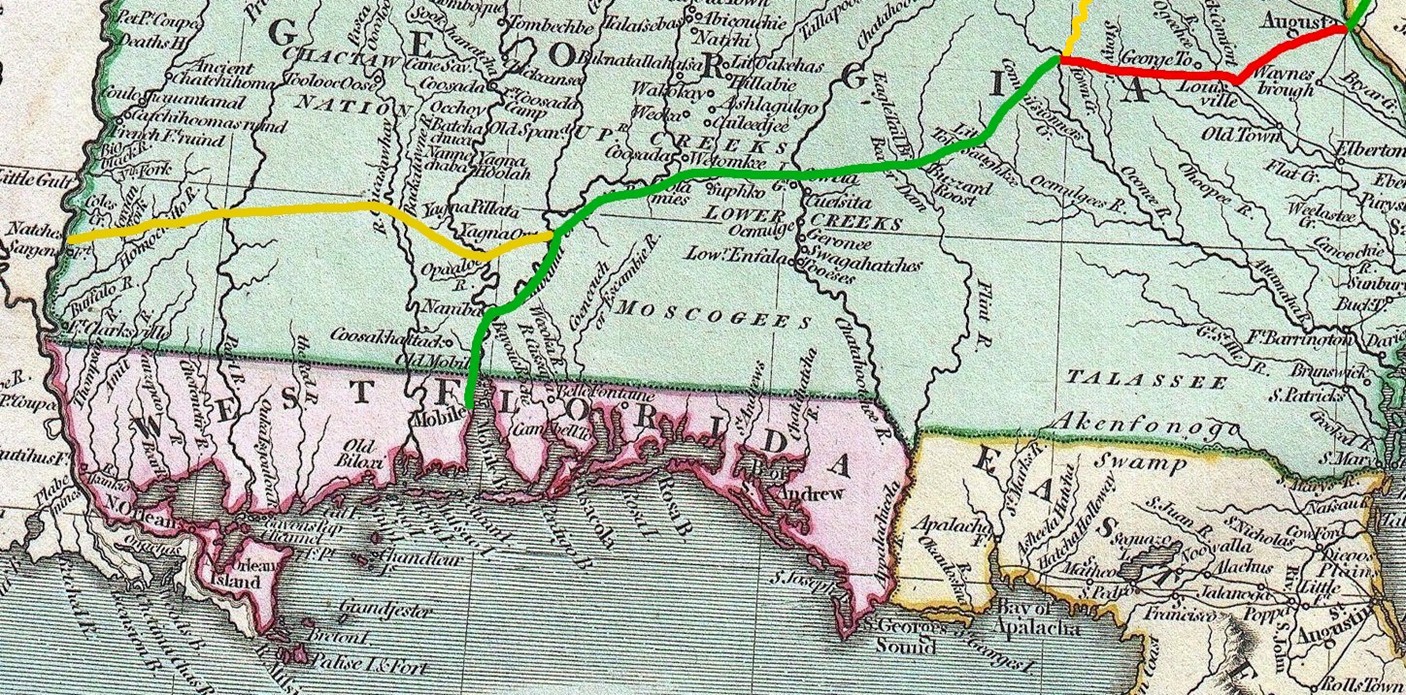
After the Revolution and before the War of 1812, several Indian paths led from the Upcountry of the Carolinas down to the Tennessee River and then down to Mississippi. Additionally, following the Great Wagon Road, settlers from the Carolinas moved south into Georgia. But, there were no available paths from eastern Georgia through Alabama to Mississippi; as this was Creek Indian lands.
By 1805 the Great Wagon Road was well established including way-houses and stage-coaches. Migrating south to Georgia would have been fairly comfortable. But once across the Savannah River, things changed. Georgia had few roads and little infrastructure. The road from Augusta, the southern terminus of the Great Wagon Road, to the new Capitol of Milledgeville would have been arduous at best. And, conditions went downhill from there.
As the US Government now controlled the new Mississippi Territory–Alabama and Mississippi–there was a need to connect the settlers of eastern Georgia going west to the settlements of Mobile Bay and the Tombigbee River and the settlements of the Natchez District of old Spanish Florida (now Mississippi). But in the first decade of the 1800s, there wasn’t an Indian path which headed directly toward Mississippi which they could follow. Of note, we know there were Indian paths; as the Creeks had settlements at old Muscogee and Coweta on the Chattahoochee River. Heading west, the challenge was to connect Milledgeville to the Chattahoochee River and the Creek Indian paths. And heading east, the challenge was to connect the new settlements in Mississippi west of the Pearl River to the Tombigbee River and Mobile Bay in Alabama.
So in 1807, the US Army forged a trail west from Milledgeville GA and east from the Pearl River in Mississippi. We know that the western section of the road was marked by three blazes of an ax on a tree. Thus, the Three-Chopped Way was born. It is not certain that the remaining section of the road heading all the way to Milledgeville GA was marked in a similar manner.
Wars make roads essential. Therefore by 1813, the Army widened the section of the road from Milledgeville GA heading west to Ft. Stoddert AL at Mobile Bay so that wagons could traverse the path. And, the improved section, named the Federal Road, eventually extended all the way to New Orleans.
Later, the section from Natchez MS through Monticello MS through Winchester MS to St. Stephens AL, including the shortcut through Ft. Claiborne AL to the intersection with the improved Federal Road at Burnt Corn AL was upgraded to accept wagons. And with the improvements, the old Three-Chopped Way was renamed the Post Road; as the US Mail traveled every three weeks west from Georgia to Mississippi.